Sunday, 11 December 2011

Safe clean drinking water

VIDEO - Water
VIDEO - Water 2
VIDEO - Water scarcity


Approximately a billion people live without clean drinking water. Imagine if your taps went dry. What would we do? Would you walk to your park to get dirty water for your family as millions of mothers in Africa do every day. More than a six-hour journey to get water each day. The lack of clear and clean water, causes disease. And thousands live their days without the bare necessities. Weakened bodies sadden the heart, one billion people do without. It tears the whole world apart. We call this the water crisis. It's a crisis because every living being needs safe clean drinking water.
Because the accessibility to water affects everything in our life. As human beings need dirt-free and unpolluted drinking water.

Friday, 9 December 2011

Factors affecting density of population

Population density is the number of people per square kilometer or mile.
This may be calculated for a county, city, country, another territory, or the entire world.

Monday, 5 December 2011

Lightning


Lightning has fascinated humans for a long time.


A thunderstorm, also known as a lightning storm, is a form of weather characterized by the presence of lightning and its sound effect on the Earth's atmosphere known as thunder.

The clouds at the high levels of the thunderstorm are made of ice crystals. The formation of ice in a cloud is an important element in the development of lightning. Positively charged ice crystals rise to the top of the thunderstorm and negatively charged ice particles and hailstones drop to the middle and lower parts of the storm.

If the negatively charged area at the bottom of the storm gets large enough, sends out a channel toward the ground called a step leader. It is invisible to the human eye and moves in steps toward the ground. When the step leader nears the ground, it repels all the negatively charged in the surrounding area, and attracts all the positive charge. As the positive charges collect in high enough concentration, they send out small bolts of ground to air lightning called streamers. If the streamers can make contact with the step leader, an electric current wave propagates up the channel as lightning.


Sunday, 4 December 2011

The Netherlands - a low-lying country

The Netherlands is a geographically low-lying country.
About 27% of The Netherlands and 21% of its population located below sea level, and 50% of its land lying less than one metre above sea level.


Monday, 28 November 2011

The Gulf Stream


The world's oceans move constantly. Ocean currents flow in complex patterns and are affected by the wind, the water's salinity and temperature, the shape of the ocean floor, and the earth's rotation.
The Gulf Stream is one of the strongest ocean currents in the world. The Gulf Stream is a warm, Atlantic ocean current that originates at the tip of Florida, and follows the eastern coastlines of the United States and Newfoundland before crossing the Atlantic Ocean. At about 40°N 30°W, it splits in two, with the northern stream crossing to northern Europe (the North Atlantic Drift) and the southern stream recirculating off West Africa. The Gulf Stream influences the climate of the east coast of North America and the west coast of Europe.
The Gulf Stream brings warmth to the west coast of Europe and is the reason we have mild winters. Without this steady stream of warmth the British Isles winters are estimated to be more than 5°C  cooler, bringing the average December temperature in London to about 2°C.

Thursday, 24 November 2011

Köppen - climate classification system


Wladimir Köppen (1846-1940), was a Russian-born German climatologist who developed a systematic method of classifying the climates of the world based on long-term patterns of the distribution of temperature and precipitation around 1900. His classification remains the most used climate classification system up to the present day.


Köppen – climate classification system
examples
Tropical climates

Af
Tropical rainforest climate

Belém, Brazil
Aw
Tropical wet and dry / savanna climate
Lagos, Nigeria
Dry (arid and semi-arid) climates
BS
Steppe climate
Denver, Colorado, United States
BW
Desert climate
Dubai, United Arab Emirates
Temperate climates
Cs
Mediterranean climate, dry season in the summer
Barcelona, Spain
Cw
Temperate maritime climate, dry season in the winter
Zhengzhou, China
Cf
Temperate maritime climate, no dry season
Roermond, The Netherlands
Continental climates
Df
Continental climate, no dry season
Chicago, Illinois, United States
Dw
Continental climate, dry in the winter
Vladivostok, Russia
Polar climates
ET

Tundra climate
Vardø, Norway
EF

Ice Cap climate
Antarctica
EH

Highland climate
The Himalayas


Köppen – climate classification system - world map


Irrigation for agriculture

The next maps shows the world's most populated areas depend on irrigation for agriculture.


VIDEO - Irrigation for agriculture

Agriculture and irrigation have affected the rise and fall of many great civilizations. Without agriculture, our way of living would cease to exist as it does today. Without irrigation, we would not have agriculture.

Agriculture
Agriculture is the farming of crops. It provides most of the world's food supply and helps support the economy.

Irrigation
Irrigation is the act of moving water from one place to another and is used in farming to water crops.


Wednesday, 23 November 2011

The Water cycle


VIDEO - The Water cycle

VIDEO - The Water cycle 2


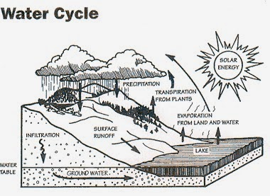
The water cycle, also known as the hydrologic cycle, describes the continuous movement of water on, above and below the surface of the Earth. Water can change states among liquid, vapour, and solid at several places in the water cycle.

The sun, which drives the water cycle, heats water in oceans and seas. Water evaporates as water vapour into the air. Rising air currents take the vapour up into the atmosphere where cooler temperatures cause it to condense into clouds. Air currents move water vapour around the globe, cloud particles fall out of the sky as precipitation. Some precipitation falls as snow or hail.

Most water falls back into the oceans or onto land as rain, where the water flows over the ground as surface runoff. A portion of runoff enters rivers in valleys in the landscape, moving water towards the oceans. Not all runoff flows into rivers, much of it soaks into the ground as infiltration. Some water infiltrates deep into the ground and replenishes aquifers, which store freshwater for long periods of time.

Over time, the water returns to the ocean, where the water cycle started.


Wednesday, 16 November 2011

Original vegetation of the world

Deserts of the world


Deserts cover about one-seventh of the earth's land surface. Desert regions cover 35% of the earth's surface.
Deserts are landscape forms or regions that receive little precipitation. They are cold at night and since the desert air is dry it holds little moisture. Desert regions receive an average annual precipitation of less than 250 mm.

European peninsulas

Colonization


Colonization is when a group or groups or countries take over an area. Once in the area, the groups will set up settlements. These overseas settlements were called colonies. An example would be the early Dutch settlers in South Africa.

Tuesday, 15 November 2011

Friday, 11 November 2011

Five major circles of latitude

There are five major circles of latitude, listed below from north to south.

·         Arctic Circle (66.5° N)
·         Tropic of Cancer (23.5° N)
·         Equator (0° latitude)
·         Tropic of Capricorn (23.5° S)
·         Antarctic Circle (66.5° S)


Picture 1 of Tropic of Cancer


These circles of latitude, excluding the Equator, mark the divisions between the five principal geographical zones.


Tropics

Also referred to as the torrid zone or tropical zone, all the water and land of the earth between the Tropic of Cancer and the Tropic of Capricorn. The tropics experience at least one day per year in which the sun passes directly overhead.


Tropic of Cancer

A line of latitude located at 23.5° north of the equator. The Sun is directly overhead the Tropic of Cancer on the summer solstice in the Northern Hemisphere (June 20 or 21). It marks the northernmost point of the tropics, which falls between the Tropic of Cancer and the Tropic of Capricorn.


Tropic of Capricorn

A line of latitude located at 23.5° south. The Sun is directly overhead the Tropic of Capricorn on the summer solstice in the Southern Hemisphere (Dec. 20 or 21). It marks the southernmost point of the tropics.


Arctic Circle

A line of latitude located at 66.5° north, delineating the Northern Frigid Zone of the Earth.


Antarctic Circle

A line of latitude located at 66.5° south, delineating the Southern Frigid Zone of the Earth.


File:Earth-lighting-summer-solstice EN.png

The creation of a rain shadow

Mountain ranges force air to rise along the windward side of the range; clouds form and precipitation falls. On the leeward side, dry air descends and warms. Little precipitation falls on this side, creating a rain shadow.

Creation of a rain shadow


Leeward: The side of a land mass sheltered from the wind—the opposite of windward.

Windward: The side of a land mass facing the direction from which the wind is blowing—the opposite of leeward.


Rain Shadow:The dry region on the leeward side of a mountain (the side sheltered from the wind). A place deprived of heavy rains because of a range of mountain sheltering it.


Evaporation, condensation, and precipitation cycles

Solar energy drives a cycle of evaporation, condensation, and precipitation.

Evaporation, condensation, and precipitation cycles

Variation in sunlight

Areas in the tropical regions receive sunlight directly. Regions further north and south receive incoming solar radiation at an angle, which reduces the heat and energy that reaches these areas.


Variation in incident sunlight


The sunlight intensity on some parts of the earth significantly varies over the course of the year as the earth changes its orientation in space. Seasonal variation in solar input occurs because the Earth is tilted on its axis by 23.5˚. As Earth orbits the sun, its orientation to the sun changes.
Winter in the northern hemisphere occurs as the northern tip of the planet tilts away from the sun. During this time, the southern hemisphere receives greater solar input and experiences summer. As Earth reaches the opposing point of its orbit and the northern hemisphere becomes angled toward the sun, the seasons reverse. Tropical regions experience relatively minor changes in temperature, and their seasons are characterized by the presence or absence of rain.


Temperature

One of the most important climatic factors is temperature and it generally decreases with increasing latitude (as you go north) and altitude (as you go up).
In fact, scientists have determined that for every 1000 meters that we go up in altitude, there is a decrease in temperature of about 6 ° C.


That is equivalent to increase our latitude a linear distance of 500 to 750 km at the same elevation.

This rule, often called Humboldt's Rule, predicts that the plant communities will transform similarly with changes in temperature and altitude.

Relationship between latitude and altitude, copyright 1990 Wadsworth, Inc.

Languages in Europe

Tuesday, 8 November 2011

Tariffs


Tariffs are custom taxes that are imposed on imported goods. This raises the price of the import and gives an advantage to domestic products within that market. Tariffs are a barrier to trade and are used to protect a domestic industry.


VIDEO - Will tire tariffs cost consumers?

The American President is placing a 35 percent tax on tires made in China after labor unions complained that Chinese imports were forcing U.S. workers out of their jobs. What is the reaction to this news? Will these tariffs help decrease unemployment rates, or will they merely hurt consumers?

Wednesday, 2 November 2011

Five factors that affect climate

VIDEO - Five Factors that Affect Climate

The five factors that affect climate:

- altitude
- latitude
- near mountain range / topography
- distance to the sea
- prevailing winds / ocean currents


.

Monday, 31 October 2011

Africa - SWOT analysis


Helpful
Harmful

Internal
Strengths
·     Africa is a continent filled with possibilities for tourism 
·     Focus on environmental issues: Wildlife conservation (example: protecting Madagascar’s biodiversity)  
·     Developing financial industry and shipping industry (example: South Africa)  
·     Crude oil resources (example: Nigeria)
·     Africa ranks first in the world in the concentration of the world's largest accumulated reserves of gold, antimony, bauxite, chromium, cobalt, diamonds, fluorspar, hafnium, manganese, phosphate rock, platinum metals, titanium, vanadium, vermiculite and zirconium.
·     Growing domestic market
·     Low cost of production
·     Availability of manpower
Weaknesses
·     Poverty / employment structure
·     HIV / AIDS
·     Corruption (example: Nigeria)
·     Favouritism
·     Internal conflicts (civil war) and refugees
·     High Unemployment
·     Urbanisation
·     Access to clean water
·     Education and literacy
·     Discriminatory Problems
·     Gender inequality
·     High Unemployment Rate
·     Absence of important skills
·     Poor infrastructure hindering competitiveness
·     Desertification (example: Sahel)
·     Deforestation (example: rainforests in Congo Democratic Republic)
·     Only forty-six percent of people in Africa have safe drinking water
·     The weakness of the African states
·     The biggest risk to African wildlife today is the habitat destruction


External
Opportunities
·     Continuous pressure on multinationals to reduce cost and the multinationals move different stages of the production process to countries with lower costs
·     China and India, Asia's two emerging powerhouses, have made no secret of their desire to engage with resource-rich Africa as they seek new economic partnerships to fuel their booming economies.
·     Potentials for innovation and entrepreneurship
·     Fifa world cup (example: South Africa in 2010)

Threats
·     Protectionism
·     Cholera Outbreak
·     Interstate conflicts, refugees and terrorism
·     Competition from other low cost countries
·     Africa suffers from global warming
·     The African population is more at risk from rising food and energy prices
·     Africans are severely affected by the inequities of the current international trading system
·     Increased trade barriers


.

Tuesday, 25 October 2011

The Ecological Footprint

The ecological footprint is a measure of human demand on the Earth's ecosystems. The ecological footprint is measured by looking at resources needed to provide raw materials plus land on which to build and to absorb CO2 from burning fossil fuels.


It is a standardized measure of demand for natural capital that may be contrasted with the planet's ecological capacity to regenerate.It represents the amount of biologically productive land and sea area necessary to supply the resources a human population consumes, and to assimilate associated waste. 

Using this assessment, it is possible to estimate how much of the Earth (or how many planet Earths) it would take to support humanity if everybody followed a given lifestyle.


The next drawing shows the ecological footprint. The extent of the human demand in hectares per person. It is measured by looking at resources needed to provide raw materials plus land on which to build and to absorb CO2 from burning fossil fuels.


VIDEO - UAE Ecological Footprint Animation- English


VIDEO - The Ecological Footprint explained by Mathis Wackernagel


VIDEO - National Geographics - The Ecological Footprint 1/10


.