Wednesday, 26 September 2012

Melting pot

Melting pot.

In the eighteenth and nineteenth century, the metaphor of a (s)melting pot was used to describe the fusion of different nationalities, ethnicities and cultures.

It was used together with concepts of the United States as an ideal republic and a "city upon a hill" or new promised land.

It was a metaphor for the idealized process of immigration by which different nationalities, cultures,  nationality, ethnicity and race were to blend into a new community /society.


The ethnic mosaic or the salad bowl concept suggests that the integration of the many different cultures of United States residents combine like a salad, as opposed to the melting pot.
In the ethnic mosaic or the salad bowl model, various American cultures are juxtaposed — like salad ingredients — but do not merge into a single homogeneous culture. Each culture keeps its own distinct qualities. This idea proposes a society of many individual, "pure" cultures in addition to the mixed culture that is modern American culture, and the term has become more politically correct than melting pot, since the latter suggests that ethnic groups may be unable to preserve their cultures due to assimilation.

Tuesday, 25 September 2012

Meanders and Oxbow Lakes


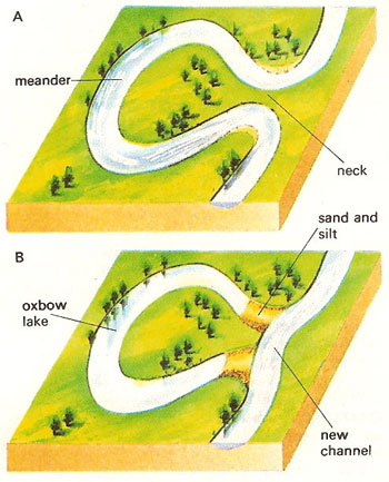
A meander is a bend in a river. A meander is formed when the moving water in a stream erodes the outer banks and widens its valley. 


The eroding sediments from the outside of a bend are deposited on the inside. The result is a snaking pattern as the stream meanders back and forth. 


When a meander gets cut off from the main stream, an oxbow lake is formed.


The stages of formation of an oxbow lake:

Stage 1 - Continual erosion of the outer banks of a meander by processes such as hydraulic action causes the neck of the meander to become narrower and narrower.


Stage 2 - Eventually as the neck becomes increasingly narrow, the two outer bends meet and the river cuts through the neck of the meander. The water now takes the shortest route rather than flowing round the bend. The fastest current is in the centre and deposition is likely at the sides. This deposition begins to seal off the old meander from the rivers new channel.


Stage 3 - Eventually deposition completely seals off the old meander and the old meander bend is left isolated as an ox-bow lake. Over time this feature is likely to fill with sediment and dry up (except for periods of heavy rain). The feature left behind when the water dries up is known as a meander scar.


Incredible volcano video

The most incredible volcano video of all time.

The most incredible volcano video ever shot. Geologists Geoff Mackley, Bradley Ambrose and Nathan Berg became the first people ever to get this close to Marum Volcano's famed lava lake on Ambrym Island, Vanuatu. 

Vanuatu is an island nation located in the South Pacific Ocean. The archipelago, which is of volcanic origin, is some 1,750 kilometres east of northern Australia, 500 kilometres northeast of New Caledonia, west of Fiji, and southeast of the Solomon Islands, near New Guinea.


Coming within 30 metres of the lava lake down a watercourse, it was possible to stand the heat for only 6 seconds. With Fire Brigade breathing apparatus and heat proof proximity suit it was possible to stand on the very edge and view the incredible scene.


The short version of the video:


The long version of the video:


Monday, 24 September 2012

Top 10 world's largest cities

The ten most populated cities in the world ranked in order by their metropolitan populations.


1. Tokyo, Japan - population: 32.5 million

2. Seoul, South Korea - population: 20.6 million
3. Mexico City, Mexico - population: 20.3 million
4. New York City, New York - population: 19.8 million
5. Mumbai, India - population: 19.2 million
6. Jakarta, Indonesia - population: 18.9 million
7. São Paulo, Brazil - population: 18.8 million
8. Delhi, India - population: 18.6 million
9. Shanghai, China - population: 16.7 million
10. Manila, Philippines - population: 16.3 million


Sunday, 23 September 2012

Economic development and human development indicators


Development often takes place in an uneven way. A country may have a very high GDP - derived, for example, from the exploitation of rich oil reserves - while segments of the population live in poverty and lack access to basic education, health and decent housing.
Hence the importance of human development indicators, measuring the non-economic aspects of a country's development.


Studying development is about measuring how developed one country is compared to other countries, or to the same country in the past. Development measures how economically, socially, culturally or technologically advanced a country is. The two most important ways of measuring development are economic development and human development.


Economic development indicators


Economic development is a measure of a country's wealth and how it is generated (for example agriculture is considered less economically advanced then banking).


To assess the economic development of a country, geographers use economic indicators including:

  1. GNP per capita - is a country's GNP divided by its population. Per capita means per person. (GNP measures the total economic output of a country, including earnings from foreign investments).
  2. Economic growth - measures the annual increase in GDP, GNP, GDP per capita, or GNP per capita.
  3. Inequality of wealth - is the gap in income between a country's richest and poorest people. It can be measured in many ways, (eg the proportion of a country's wealth owned by the richest 10 per cent of the population, compared with the proportion owned by the remaining 90 per cent).
  4. Inflation - measures how much the prices of goods, services and wages increase each year. High inflation (above a few percent) can be a bad thing, and suggests a government lacks control over the economy.
  5. Unemployment - is the number of people who cannot find work.
  6. Economic structure - shows the division of a country's economy between primary, secondary and tertiary industries.
  7. Demographics - study population growth and structure. It compares birth rates to death rates, life expectancy and urban and rural ratios. Many LEDCs have a younger, faster-growing population than MEDCs, with more people living in the countryside than in towns. The birth rate in the UK is 11 per 1,000, whereas in Kenya it is 40.


Human development indicators


Human development measures the access the population has to wealth, jobs, education, nutrition, health, leisure and safety - as well as political and cultural freedom. Material elements, such as wealth and nutrition, are described as the standard of living. Health and leisure are often referred to as quality of life.


To assess the human development of a country, geographers use human indicators including:


  1. Life expectancy - the average age to which a person lives, eg this is 79 in the UK and 48 in Kenya.
  2. Infant mortality rate - counts the number of babies, per 1000 live births, who die under the age of one. This is 5 in the UK and 61 in Kenya.
  3. Poverty - indices count the percentage of people living below the poverty level, or on very small incomes (eg under £1 per day).
  4. Access to basic services - the availability of services necessary for a healthy life, such as clean water and sanitation.
  5. Access to healthcare - takes into account statistics such as how many doctors there are for every patient.
  6. Risk of disease - calculates the percentage of people with diseases such as AIDS, malaria and tuberculosis.
  7. Access to education - measures how many people attend primary school, secondary school and higher education.
  8. Literacy rate - is the percentage of adults who can read and write. This is 99 per cent in the UK, 85 per cent in Kenya and 60 per cent in India.
  9. Access to technology - includes statistics such as the percentage of people with access to phones, mobile phones, television and the internet.
  10. Male/female equality - compares statistics such as the literacy rates and employment between the sexes.
  11. Government spending priorities - compares health and education expenditure with military expenditure and paying off debts.


The Human Development Index (HDI)

The Human Development Index (HDI) is a composite statistic used to rank countries by level of "human development".

The Human Development Index (HDI) is a comparative measure of life expectancy, literacy, education, standards of living, and quality of life for countries worldwide. 

It is a standard means of measuring well-being, especially child welfare. It is used to distinguish whether the country is a developed, a developing or an underdeveloped country, and also to measure the impact of economic policies on quality of life.

HDI is measured between 0 and 1. The Netherlands has an HDI of 0.910 whereas Kenya has an HDI of 0.509. And Chad has an HDI of 0.328.


Introduction to Tectonics

`